Niokolo-Koba National Park (Niokolo-Koba)
The Niokolo-Koba National Park (Parc National du Niokolo Koba, PNNK) is a World Heritage Site and natural protected area in south eastern Senegal near the Guinea border. It is served by Niokolo-Koba Airport, an unpaved airstrip.
Established as a reserve in 1925, Niokolo-Koba was declared a Senegalese national park on 1 January 1954. Expanded in 1969, it was inscribed as a World Heritage Site in 1981 as a UNESCO-MAB Biosphere Reserve. In 2007 it was added to the UNESCO List of Endangered World Heritage sites.
Since 2005, the protected area is considered a Lion Conservation Unit.
Map - Niokolo-Koba National Park (Niokolo-Koba)
Map


Country - Senegal
 |
 |
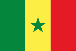
| Flag of Senegal | |
Senegal is notably the westernmost country in the mainland of the Old World, or Afro-Eurasia. It owes its name to the Senegal River, which borders it to the east and north. The climate is typically Sahelian, though there is a rainy season. Senegal covers a land area of almost 197000 km2 and has a population of around million. The state is a unitary presidential republic; since the country's foundation in 1960, it has been recognized as one of the most stable countries on the African continent.
Currency / Language
| ISO | Currency | Symbol | Significant figures |
|---|---|---|---|
| XOF | West African CFA franc | Fr | 0 |
| ISO | Language |
|---|---|
| FR | French language |
| WO | Wolof language |